Policy Notes - October
A “worst case scenario” permit for cedar restoration finally explained at the Pinelands Commission.
Trust Us, It’s Only a Pilot: What Happened When the DEP Brought the Wharton Cedar Plan to the Pinelands Commission
On October 9, NJDEP’s Forest Service finally explained, out loud and in public, what it intends to do with 171 acres of Atlantic white cedar swamp in Wharton State Forest. The Pinelands Commission then approved the application. Only two commissioners voted no.
The plan, as explained
DEP’s presenters, Todd Wyckoff and Bill Zipse of the NJ Forest Service, described Unit 1 as the first of a twelve-unit plan covering roughly 2,300 acres in Wharton, and as a pilot for restoring cedar in perpetuity. They explained why reviewers should focus on growing space rather than the number of cords of wood to be removed. They explained their rationale by which trees will be judged to leave the big windfirm trees as seed sources. They also said the application is a “worst case scenario” because “we’re asking for permission. That’s the permit.” The 2,475-cords of cedar figure—which would have been 42% of the total harvest—was the high end of the estimate, they explained.
Details like this had sparked major criticism, as removing this much cedar seems antithetical to the goal of restoring the cedar. With only the written permit application to go off of, public commentaries on the plan were justified in their skepticism. These concerns were underscored at the September 11 meeting of the Pinelands Commission meeting, when loggers and sawyers showed up in force to praise the plan that they said would bring valuable cedar to their sawmills. DEP staff have since assured us that there is significant daylight between the terms of the permit and what their staff actually intends to do. We appreciate that, but it puts the public in an uncomfortable position, and DEP in one too, given the history at Glassboro Wildlife Management Area and Sparta Mountain that has made many people wary of forest management projects. Being asked to read between the lines isn’t a comfortable place for us either, which is why Pinelands Alliance launched a petition outlining the expectations that we are holding them to.
Some of what we heard during the presentation to the Pinelands Commission on October 9 was reassuring. The herbicide limits (no more than three treatments in ten years, with at least one growing season between) were called unprecedented by a staffer with 26 years of experience. Glyphosate, we were told, is “not a primary option, likely not even a second option.” Monitoring commitments exist. No one at the table disputed that cedar restoration is a worthy goal, and neither do we.
But “we’re asking for permission for the worst case” is exactly the problem.
The commissioners who read the room, and the site
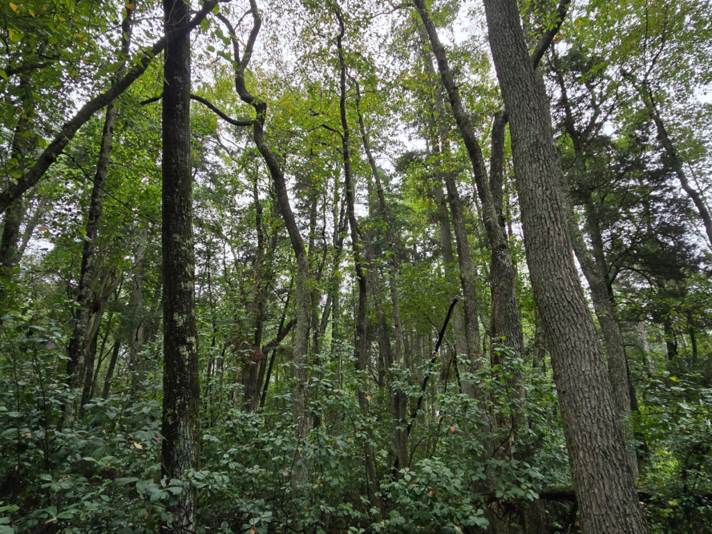
Commissioner Mark Lohbauer visited the site himself and took photographs. He told his colleagues that in places he saw “a dense population of Atlantic white cedar as far as I could see in all directions,” trees “over 60 feet tall” and “at least 14 inches in diameter,” with seedlings coming up beneath them. His conclusion: “what we have is a healthy mature robust Atlantic white cedar forest in much of the 171 acres.” He agreed that other areas, dominated by maple and black gum, are good restoration candidates, but said “I have real concern about giving a blanket authority to this 171 acre site.” He asked directly whether any acreage already meets the project’s goal. The answer was that DEP didn’t believe such areas exist on site—which is very concerning, based on our observations in the target area.
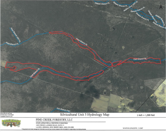
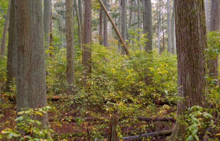
Commissioner Lohbauer asked again, a different way. The answer again described the forest overall and the next generation of cedar DEP hopes to grow. In short, it was a non-answer. This is the question we have been asking since the application surfaced: if large swaths of the project area already look and function like the end goal, why are they inside the red line? Lohbauer was not asking which technique to use on those stands. He was asking whether to touch them at all. The presenters kept answering the first question.
Commissioner Jessica Rittler-Sanchez, after complimenting the presentation, put the central problem plainly: “I can’t say that your application comes anywhere close to concluding what you just gave us, and that worries me… what you intend to do and what you explained that you’ve done before makes a lot more sense than what I was reading in the application.” She had also visited a mature stand on the site, describing it as “a spiritual experience,” and said she worried about what would happen if that area wasn’t protected in the plan. As a reviewer, she said, she can’t approve the worst case for 171 acres when DEP says it needs far less: “I’ll let you go 75 miles an hour even if you tell me you’re only going to need to go 30 and it’s okay.” DEP’s reply: “those are fair criticisms and I know we’re asking for quite a bit of trust here.”
Both commissioners voted no. After a weighty seven-second pause, in Rittler-Sanchez’s case.
The part about public participation
Here is where the Commission itself deserves scrutiny.
The application was 92 pages. Lohbauer said he wasn’t convinced it was easy for the public to access, and that “we’ve not given the public adequate opportunity to evaluate” it. He had submitted eleven questions, which staff paraphrased into a memo to DEP, and he had photos from his site visit that he was not permitted to share. Executive Director Susan Grogan and Stacey Roth explained that on the Attorney General’s advice, no new information was sent to anyone, because “the record is closed” and this is “a quasi-judicial decision.” Lohbauer’s response was the sharpest line of the day: “so we’re honoring the letter of the law, I understand that… but we’re not honoring the spirit of the law.”
Then came the asymmetry. The DEP applicants stood up and explained, at length, what the application meant, what DEP really plans, and what it has done elsewhere. Members of the public who spoke noted the contradiction: DEP could add information to a closed record, but commissioners couldn’t circulate their photos and the public couldn’t ask questions. Pinelands Alliance staff Jason Howell, put it this way: “all we have to go on is a closed record and an inability to add new information, but the applicant was clearly able to add new information.” Another, Tina Cooper, said what she heard from forestry “was not reassuring to me,” and that she is “gravely concerned about the free pass that they just got.”
To DEP’s credit, its staff acknowledged gaps. One presenter said, “If there are gaps and we’re getting questions, we’re going to try to get you better applications that cover those in the future,” and another described the project as a pilot they want to make inclusive and transparent, though that is “hard to translate into a permit application.” Commissioner Mauriello said that “perhaps in the future when the next plans come about, we can have this dialogue a little bit earlier in the process.” We agree. But the takeaway for DEP should be that it can’t rely on the Commission’s minimal notice process to carry a major project to the public. If an agency wants transparency, it has to do the outreach itself, before the record closes.
Where this leaves us
A pilot that is 1.6% of the whole pie, a worst-case permit, a closed record, and a presentation that revised the application after the public comment period. The Commission approved it, with Commissioners Lohbauer and Rittler-Sanchez dissenting, and with commissioners across the spectrum saying they’d like the rules and the process to work differently next time.
We’ll hold them to that. If DEP’s real intent is to leave mature stands alone, put it in writing and put it on the map. If mature cedar was never meant to be cut, take it out of the plan. And if the next eleven units are coming, the public deserves the materials, the maps, and the questions answered before the record closes, not after.
Local Climate Change Adaptation Planning
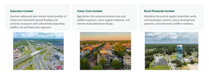
We haven’t heard many presentations dedicated to the topic of climate change since the Pinelands Commissions own climate change committee was dissolved at the end of 2024. At the September meeting of the P&I Committee (CMP Policy & Implementation), the commission heard about pilot projects that were conducted in three Pinelands towns (Evesham Township, Egg Harbor City, and Woodbine Borough) with technical assistance from Sustainable Jersey.
Climate adaptation has a patchwork problem: plenty of good programs, few of which touch the underlying causes. Many of those causes trace back to outdated zoning. Past development patterns created today’s urban heat islands and flooding corridors, and climate change is making both worse. In 2021, New Jersey amended its municipal land use law (MLUL) to address this at the town level.
Towns are now required to perform a climate change-related hazard vulnerability assessment as part of their master plans. This is a significant undertaking, as even just gathering all of the necessary data across the municipality alone can take 6-12 months. Sustainable Jersey received funding from NJDEP’s Resilient NJ fund to assist towns with this, and test out a model that other towns can follow—hopefully making their path easier and more efficient.
The core question is deceptively simple. Things may look fine with today’s mix of buildings and vacant lots, but what happens if a town builds out everything it has zoned for, and then layers current and projected climate impacts on top? Towns must now run that buildout analysis using the latest DEP climate science and hazard data to pinpoint where residents will be most vulnerable. Where do people experience the most extreme heat, for example, and where should tree planting and cooling centers go to address it?
Different towns present different challenges. For example, Woodbine borough is a rural town where 100% of the residents depend on private well water and septic systems (although the latter may soon change, thanks to an MOA currently working its way through the Pinelands Commission). The team analyzed how to manage stormwater without threatening groundwater quality for these wells. Given its coastal location in Cape May County, they also had to consider storm surge and other coastal hazards. Evesham, a more suburban example, presented the unique challenge of many river dams—19 to be exact and pre-existing stormwater runoff issues.
Identifying vulnerabilities is only half the job. The next step is an action plan, beginning with incorporating findings into the town’s master plan. That is what turns the assessment from a nice overview of potential problems into something the town is actually bound to act on.
Commissioner Lohbauer, who chaired the now-defunct climate committee, seemed encouraged by the presentations. “This is the first time the climate resilience goals are actually being codified into municipal master plans,” he noted, adding that “for the first time we’ll be able to—through the municipal master plan—make decisions on applications coming before us that may have very long climate resilience goals.” He also expressed optimism that this might “lead to some generic regional standards that we as a commission might identify and then try to apply through amendments to our plan.”
That last point matters, because climate change, even just the phrase itself, has yet to be meaningfully incorporated into the Pinelands Comprehensive Management Plan. Staff recently analyzed (see our summary from 2023) whether the current pace of climate change warranted changes to the map, but the effort produced only minor adjustments to encourage targeted conservation efforts and fully enforce the 300-foot wetlands buffer in certain areas. For now, the towns are ahead of the plan that governs them, which is an odd place for the region’s regulatory backbone to find itself.
Permanent Land Protection Update:
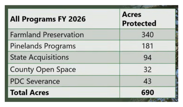
How much land is actually protected in the Pinelands? Pinelands Commission staff gave a presentation summarizing how much land had been preserved in the Pinelands during FY 2026, and the programs through which this happened. We explained how many of these programs work in a previous blog post. In total, approximately 1.1 square miles were permanently preserved.
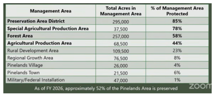
Preserved lands are not distributed equally around the Pinelands area—and that’s by design. Many aspects of the Pinelands Comprehensive Management Plan were designed to encourage development around the perimeter of the Pinelands rather than its core. Land designated as the Preservation Area District are targeted by the Pinelands Development Credit (PDC) program, which has lead to 85% of this area being preserved. Agricultural production areas are also targeted by the PDC program, which is also boosted by farmland preservation programs, resulting in preservation figures ranging from 44%-87% for the different categories.
PDC’s have experienced inflation, along with everything else in our lives, with an 8% increase in the going-rate since FY2025—this means that developers building in regional growth areas are paying a higher price ($1,897 more per right) for each PDC. This has the benefit of encouraging more preservation, as landowners may see the higher prices and consider selling their PDC’s—effectively preserving the land that they were attached to in the process.
Taken together, these efforts have protected 52% of the Pinelands’ total land area, which is no small feat for a region sitting in the most densely populated state in the nation. And every acre counts. That the comprehensive management plan has held up this well, decades on and under constant development pressure, remains something of a small miracle. But miracles, it turns out, have a lot of paperwork behind them: staff who apply the rules faithfully, and a public that shows up, testifies, and refuses to let the plan become a suggestion.
Months since the Pinelands Municipal Council Last Met: 48
